MobileScapes
Canada's most comprehensive mobile movement database
MobileScapes is now powered by cellular network data and modelled by an expert team of spatial data scientists. The data are de-identified, normalized, aggregated and/or anonymized to deliver the most accurate and representative movement profiles of the Canadian population.
In ENVISION, users can explore visiting over 130,000 ready-to-use geofences in the EA Geofence Library. A geofence is a virtual boundary around a real-world location such as a retail store, restaurant or bank. MobileScapes data are updated weekly, providing current information on locations Canadians frequent, how often they visit and how long they stay.
Our data come from de-identified cellular network signals. These signals are processed through advanced models that calibrate the observed data to represent the Canadian population. The result is foot traffic estimates grounded in real-world behaviour based on a large, consistent sample of device activity.
What’s New?
The 2026 vintage of MobileScapes is built on a redesigned data engine, integrated into the new ENVISION platform, and delivers a map-centric experience for mobile movement analysis.
A Stronger Data Foundation
MobileScapes uses cellular network data as the primary source for estimating visit volumes. These data cover a large share of the Canadian population and provide more consistent representation nationwide. A larger and more stable sample reduces day to day volatility and increases confidence in the results.
Cellular network data also deliver more consistent signals throughout the day for most devices, allowing for a more complete view of how people move throughout the day.
The model also uses other sources in estimating the patterns, including shopping behaviour from EA databases (e.g. HouseholdSpend), historical aggregated location trends and contextual information like dwell time, hours of operation, seasonality and traffic patterns.
Want to know more about mobile analytics?
Map-Centric Experience in ENVISION
MobileScapes is fully integrated into the new ENVISION platform, offering an interactive map experience. Pre calculated visit data allow users to quickly explore and analyze visit patterns directly on the map with improved performance.
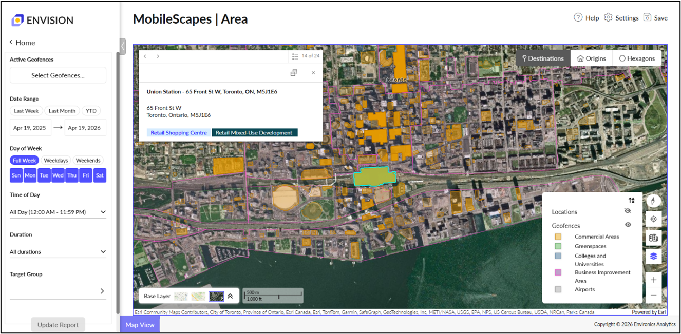
MobileScapes in ENVISION, Map View.
Key Features
- Interactive Map Visualizations: Explore visit patterns using size scaled markers by visit volume, hex grid heatmaps that reveal foot traffic density and shaded origin maps showing where visitors come from at the Forward Sortation Area (FSA) level.
- Pre Aggregated Data: All data are summarized and ready to explore, with results loading in seconds.
- Flexible Filtering: Filter results by location, banner, category, geography, date range, day of week or time of day. (Morning: 6 AM–12 PM, Afternoon: 12 PM–6 PM, Evening: 6 PM–12 AM).
- Visit Duration Insights: Analyze visits across three duration bands—under 30 minutes, 30 to 60 minutes and over 60 minutes.
- PRIZM® Target Group Filtering: Segment visit data by the 67 PRIZM® segments to understand which audiences frequent a location.
- Visitor Extract Download: Access aggregated visitor origin data at a small area geography (such as neighbourhoods or postal codes) that can be linked to other EA data. This enables deeper analysis by enriching visitor origins with demographic, lifestyle and values based attributes to better understand who visits a location and inform customer profiling, targeting and planning decisions.
Data Coverage
Data are available from January 2023 onward.
EA maintains data for the current year and the three prior years. During our annual vintage update, the oldest year is retired.
Data are updated and released weekly.


Geofence Selection in ENVISION.
Geofences and Accessing the Data
In ENVISION, the MobileScapes tool provides access to the full EA Geofence
Library, searchable by location, banner, category or geography.
The EA Geofence Library covers Canadian stores, restaurants, shopping centres, parks, entertainment venues and more.
For a complete list of categories, please refer to the latest MobileScapes EA Geofences Library – Category List.
Ready to really understand your customers?
Connect your data to mobile movement data
Privacy and Security with Mobile Movement Data
Environics Analytics is proud to be among the first Canadian organizations certified to the ISO/IEC 31700 Privacy by Design standard. Privacy-by-design is embedded throughout the development and delivery of our MobileScapes product, which uses de-identified, aggregated and/or anonymized mobile data to provide population level insights on the movement patterns of Canadians.
We work exclusively with trusted data sources (both cellular network signals and GPS locations) who meet our strict privacy, security and ethical standards. This is supported by rigorous assessments to ensure lawful collection, use and disclosure, transparency and compliance with applicable privacy laws and best practices. Our technology and processing environment are further supported by independent, third-party security certifications ensuring strong protections for data at every stage.
For more information, or to see how MobileScapes can help your analysis, please contact an EA sales representative or email our Support team.
How Is It Used?
Below are a few examples showing how MobileScapes can be used across different industries.
Media and Outcomes
Creating targeted ad campaigns and measure the results
A mall owner and their agency are trying to plan an ad campaign that will increase traffic to a midtown mall:
- Use MobileScapes to identify where current audiences are coming from. Create out of home and geo-targeted digital campaigns in those places to drive increased visits
- Target new customers by using the PRIZM segments of current visitors
- Build an OOH and a digital campaign to target the lookalikes in FSAs with reasonable proximity to the mall
- Measure change in mall traffic during and after the campaign to assess performance
Key questions:
How can I create a campaign to bring more young families to my stores?
How can I reach my PRIZM target groups using out of home advertising?


Retail and Shopping Centres
A national retail chain wants to find out where to open new store locations.
- Analyze visitation patterns and peak times at potential store locations
- Compare traffic volume estimates at competitor locations within the same banner or category
- Identify trade areas based on visit origins at the FSA level
Key questions:
Who are our shoppers and visitors and what are their interests?
How does my location’s visitation and trade area compare to competitors?
Banking and Financial Services
A bank is evaluating which branches to consolidate or renovate based on visitor patterns.
- Analyze visit estimates to different branches by day of week and time of day
- Identify areas with low foot traffic to optimize branch locations
- Filter by PRIZM target groups to understand which visitor segments frequent each location
Key questions:
How does traffic trend month over month and year over year at my branches?
Which visitor segments should we target in our next marketing campaign?